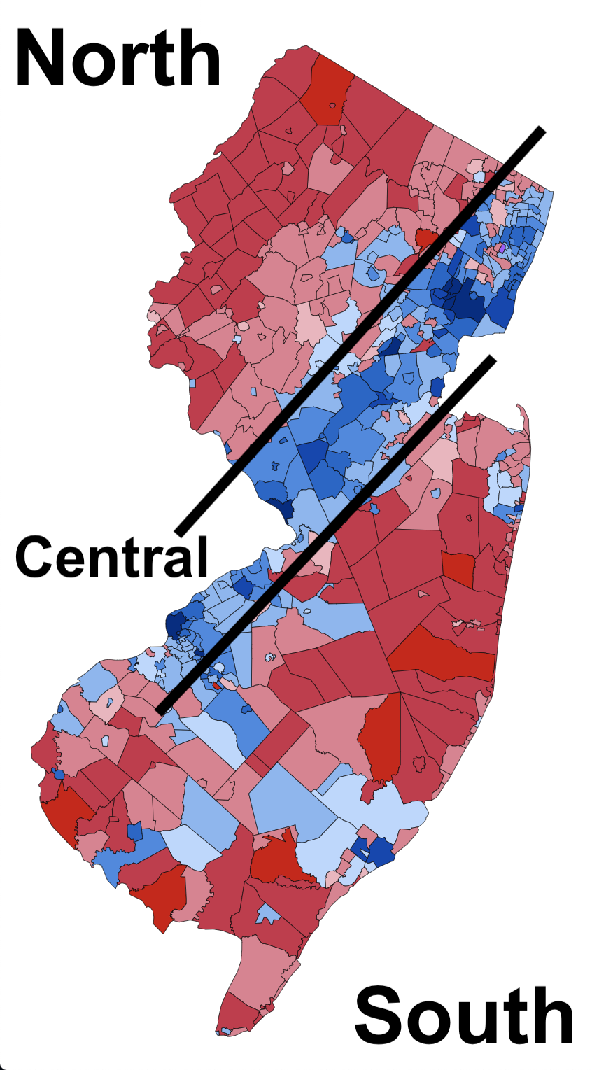
Submitted by TheseMenArePawns t3_y8a1kf in newjersey
Comments
Majestic-Unicorn33 t1_isyuofl wrote
I lived in Neptune and now Toms River and I have always considered myself Central Jersey.
jaymon1974 t1_isyuz9j wrote
This is the worst yet. Sorry.
TheseMenArePawns OP t1_isyvabs wrote
It's alright friend, it's not meant to be a joke map - just an observation.
glitterpumps t1_isyw8t1 wrote
Unhinged
stevenfrijoles t1_isyx22n wrote
If I turn my phone right 45 degrees it kind of works I guess
zapatasize t1_isyxnym wrote
I think I feel this as I move around the state. Not sure the NCS designations are right (but it works without more controversial labels). Unfortunately it represents a more serious divide (polarization) than NCS or Pork Roll/Taylor Ham...
Cheeseboy_22 t1_isyzcuj wrote
This is a good population density map, not a cultural map
toughguy375 t1_isz5g22 wrote
Hills / Fall Line / Coastal Plain
toughguy375 t1_isz68mc wrote
Not really. Brick and Toms River have as much population density as the blue suburbs. It's cultural differences.
nomaddddd818 t1_isz6yzq wrote
There’s no way Bergen County is “central” Jersey.
PirateForward8827 t1_isz7b27 wrote
The socio culture is the same in Camden as in Princeton as in West New York as in Alpine? I don't think so.
Cheeseboy_22 t1_iszbv6c wrote
Of the whole state. The line going from New York to Philly is much denser. Of the top 25 largest towns in NJ, 19 are in the "central" line. Brick and Toms River are more like outliers.
And you're saying people in Middletown have more in common with people in Atlantic city than they do with Woodbridge OR Hackensack with Camden than Wayne?
tbert56783 t1_iszcjye wrote
Socio-cultural or political?
TheseMenArePawns OP t1_iszcp4x wrote
It is technically political, but I didn’t want “political” in the post title and make it super controversial
Extra_Advance_477 t1_iszd733 wrote
I will not allow it. Get out of my courtroom
tbert56783 t1_iszh8c9 wrote
That's fair but I think it is somewhat controversial anyway....
Practical_Argument50 t1_iszmv89 wrote
You just basically outlined PSE&G (electric) territory.
gordonv t1_iszrcic wrote
Actually, this looks more of a voter's map. Ocean County is high density and republican voters.
Mr_Matt_K t1_iszs6p3 wrote
https://commons.wikimedia.org/wiki/File:2016_NJ_presidential_results_by_muni_graduated.svg
>You are free:
>to share – to copy, distribute and transmit the work
>to remix – to adapt the work
>Under the following conditions:
>attribution – You must give appropriate credit, provide a link to the license, and indicate if changes were made. You may do so in any reasonable manner, but not in any way that suggests the licensor endorses you or your use.
>share alike – If you remix, transform, or build upon the material, you must distribute your contributions under the same or compatible license as the original.
TrailChems t1_iszsgbg wrote
Also shows where the assholes live. You know who you are.
Numerous_Chef3191 t1_iszxkb1 wrote
NO
EconomySwan6300 t1_it02flp wrote
No way you just called Hudson county Central Jersey
Mr_Matt_K t1_it0fnk2 wrote
Teterboro, it tied for the presidential race in 2016
Smacpats111111 t1_it0k1kp wrote
I’ve noticed this too. Areas within 5-10 miles of the Turnpike vote blue. The others mostly vote red.
surf_AL t1_it0x9bk wrote
Is there a meaningful difference? Politics nowadays is more cultural than, like, policy driven
Conjohn1899 t1_it12q7o wrote
Thank you for this comment.
unclebonesy t1_it1t86q wrote
God bless centra New Jersey and god bless the United States of america
Intelligent_Duc t1_it1voqn wrote
Makes sense .all the worst parts of nj !!!!

TheseMenArePawns OP t1_isyuids wrote
Uh oh, did not mean for this post to be received negatively. Just thought it was interesting seeing the N/C/S split from a different angle.