Comments
[deleted] t1_j63mwsq wrote
[deleted]
Kalle_Silakka t1_j63rwoo wrote
Damn I see my cottage road from here
Wang_entity t1_j63ui9b wrote
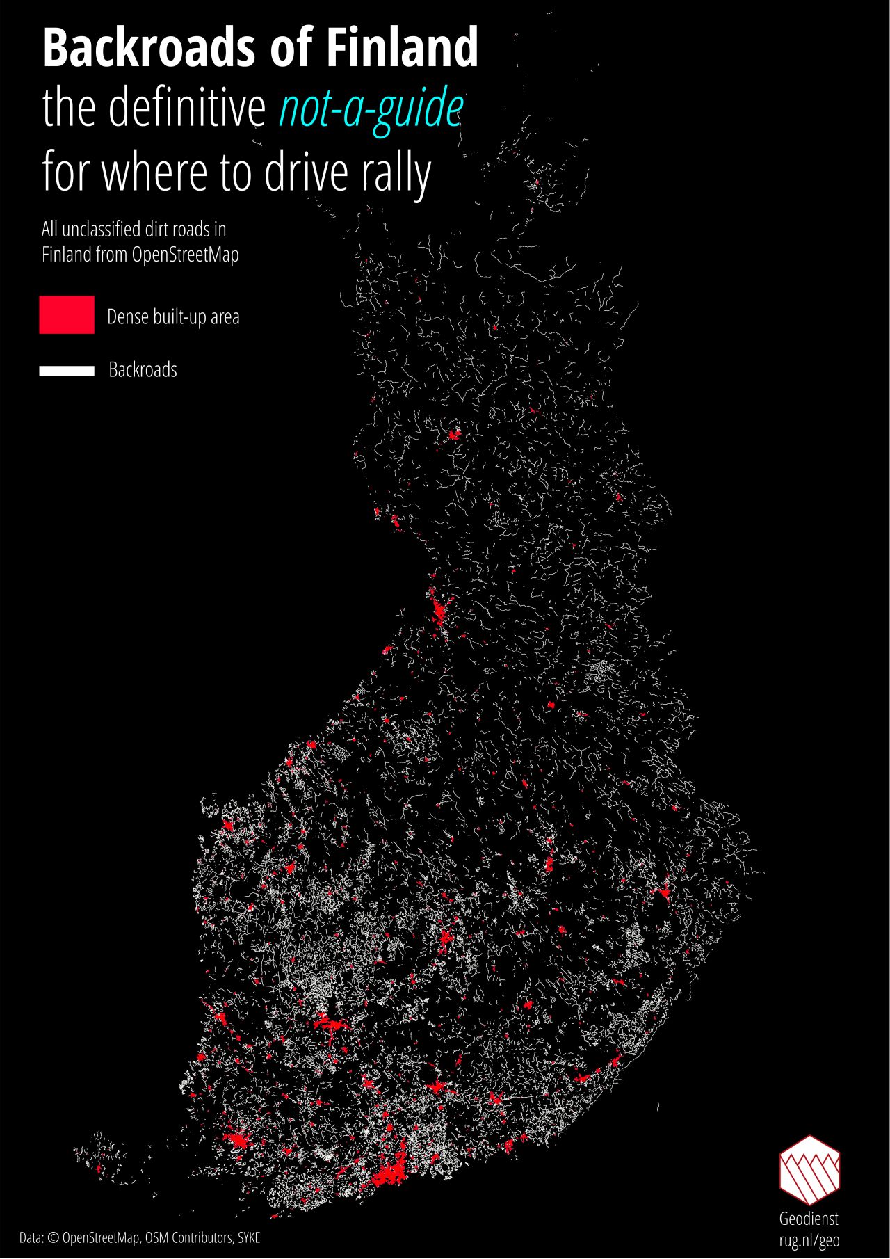
I think this map had removed all of the main roads.
Kharon8 t1_j63wcuu wrote
Yes. All of those are gravel roads, so even minor paved roads aren't in the picture. I think this pic is also based on satellite images, so no car has visited those.
Even Google Maps doesn't show all gravel roads, but when they do, it looks like this: https://goo.gl/maps/6ehKRyfYjy3jzhX56
,,,,and typical rally speed on that: 100mph or more. I think they're nuts, but exciting? Hell yeah!
(That's near by my summer cottage, not all random place.)
[deleted] t1_j63x3ex wrote
It also depends on what has been added to OpenStreetMaps. I live in area that is completely black on this map, but ofc there are plenty of backroads around, but nobody to map them / put them into OSM.
Tomino321 t1_j641ti3 wrote
Yeah, OSM in Finland is quite lacking when it comes to smaller roads especially in areas with low population
BigRiko t1_j643qh5 wrote
That's super cool! The data on OpenStreetMap never ceases to amaze me
MettaRosvo t1_j64bgqy wrote
Why is there a singular strip of backroad deep in Russian side of the border? Do we still own that particular backroad or what?
Seeteuf3l t1_j64ddth wrote
I think it shows entire road, even if it crosses the border.
ZeusTheRecluse t1_j64krba wrote
What this thread needs is a rally POV video.... https://www.youtube.com/watch?v=f_cYd7MpXgs
your welcome.
extra: 3rd party POV... https://www.youtube.com/watch?v=sC8IAJ03nZ8
ar243 t1_j64mzpn wrote
Awesome work!!
LiverOfStyx t1_j64sdsj wrote
Not even close to accurate. I know one road that is missing and how perfect it would be for rallying. My family owns a share of that road and government pays for the upkeeping and maintenance cause it is quite neat way to shortcut between two highways and can handle a tank... The whole area is a black void in this map when i know it is fully of backroads that are in excellent condition. They cut thru marshlands that form natural obstacles, unless you use those roads...
0_0_0 t1_j64x7fi wrote
My hypothesis is it's a road inside the area Finland rents from Russia for the Saimaa Canal.
Or a coordinate mistake.
voracious_villain t1_j64y8x2 wrote
Curious as to the methodology used to extract, use QGIS and OSM every day at work.
[deleted] t1_j651br7 wrote
[removed]
GhotiGhetoti t1_j654lav wrote
Not even close to accurate because they’re missing one road?
202042 t1_j658e8v wrote
Thanks! I will try this out later.
LiverOfStyx t1_j658u7u wrote
I said the whole area is just a black void.. there are dozens of them missing within.. 100km^(2)
So, more than one, more than few and yes: if the miss that much on that one area, how much more are they missing?
Engrammi t1_j658vqh wrote
Not seeing any of the roads I'd use for rally, or roads I did use for riding a moped before getting a license.
torchma t1_j65cls7 wrote
If you're going by OSM classification of roads, you should know that it's highly inconsistent. Two roads that are in fact very similar (surface, width, frequency of use) are often classified differently and vice versa. That's what you get with crowd sourced data.
I_suck_cock_for_free t1_j65e667 wrote
With Lancer Evo or Delta S4?
[deleted] t1_j65ed5u wrote
[deleted]
DaniilSan t1_j65ibru wrote
Data is from OpenStreetMap which as you may guess by it's name is open and can be edited by basically anyone and thus it often includes roads and paths Google doesn't bother to include on the map.
Sitraka17 t1_j65tpog wrote
Punaise! That's the kind of map I wanna be able to make !!
Nice work ! +1 !!!
PHX_Architraz t1_j668rja wrote
*My Summer Car intensifies*
Great map with complete and utter lack of suggestions.
MOTRHEAD4LIFE t1_j66ahxu wrote
BMW 3-Series diesel or
KisssCola t1_j66chxj wrote
Can you see the total lenght of the roads on the map? It should be over 160 000 km, that's only the total lenght of the forest roads (metsäautotie) in Finland.
I_suck_cock_for_free t1_j66g6b3 wrote
Datsun 100A is the correct answer
VapingNewb999 t1_j66h3hb wrote
That bridge though.
haararaketti t1_j67qy90 wrote
I would probably use a website like geofabrik.de to download the OSM extract and then import it into a database with osm2pgrouting. Then use a query layer in QGIS to only get the roads I want.
Vittulima t1_j67tk6i wrote
Doesn't QGIS have plugins for the download part? I remember downloading OSM (and more through ministry of transportation) data when I did something similar
haararaketti t1_j67yhds wrote
Yeah, you have quickosm. At this scale though I think the request would exceed the allowed limit and at least I’m more comfortable using PostGIS when doing anything related to networks.
Vittulima t1_j67z7pj wrote
Makes sense. For this I'd probably go over to Paituli though. They're a great source for Finnish map/location data. I've used digiroad a ton
Warm-Cranberry-6704 t1_j68u4f7 wrote
I reckon Helsinki is the most dense down there? Seems reasonable but the rest stick out
__crackers__ t1_j69bbe5 wrote
> I think this pic is also based on satellite images, so no car has visited those.
It's from OpenStreetMap, so probably the exact opposite: the tracks were plotted by a person travelling along them with a GPS.
V8-6-4 t1_j6a8a9w wrote
The only amazing thing is how many roads is missing from this map.

tilcica t1_j63lwbk wrote
why is there so many random patches of road not connected to anything? if the car went to capture there, why didnt it also capture the way there and/or back?
is it similar to germany where they had to remove large parts of it?